|
Digging through some boxes I found my old copy of Gunnar Thompson’s The Friar’s Map of Ancient America (1996), which I bought in 1997 at the gift shop at America’s Stonehenge (Mystery Hill) in New Hampshire—that collection of colonial cold cellars and foundations that generations have passed off as megalithic architecture. The pages are still reasonably white, but the cover has faded from its original electric orange to a dull rust. The book purports to demonstrate that the world map created by Albertin de Virga (c. 1414) actually depicts North America (as the blob to the northwest of Europe) and South America (as the island southeast of Asia) in the image below. (Note that southern Africa is marked as the site of the Garden of Eden!) The original map vanished into the private hands of an unnamed collector in the 1930s, and all that remains are photographs taken of it shortly before it disappeared. 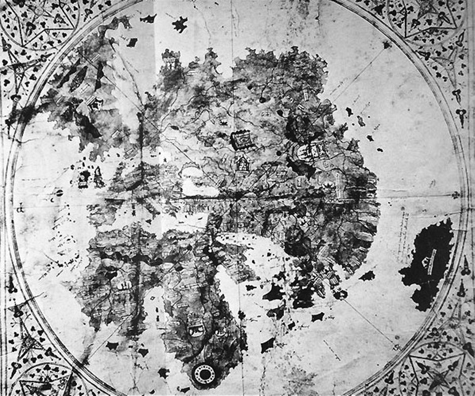
Map of the world by Albertin de Virga. Click for larger. (Wikimedia Commons)
Thompson goes to immense effort to show that this map was based on the expeditions of English friar Nicholas of Lynn between 1330 and 1360 CE. This would be extraordinary for a number of reasons, not least of which is that fact that Nicholas of Lynn was, according to extant evidence, not born until 1360. It was John Dee, the Elizabethan occultist and mystic, who first identified this Nicholas, a Carmeline monk, as the author of Inventio Fortunae due to a misinterpretation of Chaucer’s praise for Nicholas in Treatise on the Astrolabe. This book, in turn, is conveniently non-existent, rendering Thompson’s claims about its contents speculative at best. The misidentification arose because of the summary of the Inventio Fortunae preserved in Jacobus Cnoyen’s Itinerarium. The summary stated (apparently) that a Franciscan friar gave an astrolabe to a Norwegian settler on an Atlantic island. Hence the confusion with the astrolabe-using Carmeline monk, Nicholas of Lynn. Of course Cnoyen’s text is now lost, too, and with it the summary. All that remains of the Inventio Fortunae is contained in a single letter sent from Gerardus Mercator to John Dee in 1577 and a legend on Mercator’s 1569 polar map. Here is Mercator’s map text:
I don’t usually think of the myth of King Arthur as a good source for travels to North America, but I’m not an alternative historian. (To be fair, some stories do present Arthur as dealing with Iceland and Greenland, but these are very late and obvious derivatives of the narrative told in Richard Haklyut in Navigations 1.1 [1589-1600], quoting Geoffrey of Monmouth, 9.19, who in turn was merely applying to Arthur all the northern lands known in his day.) Here is Mercator’s letter to John Dee, from, I believe, the 1956 translation by E. G. R. Taylor:
Now, if you believe that a “voyage” that claimed to have found a gigantic magnetic mountain, four inrushing seas, and a polar island is an accurate and reliable source, more power to you. Certainly, early mapmakers thought as much and included this weird detail in the polar regions of their maps on the authority of the Inventio Fortunae, as well as the Classical notion of the lodestone mountain on which it was based. Authors such as Galen and St. Ambrose had written of this long ago. In the Middle Ages it was used to explain why the compass points north. 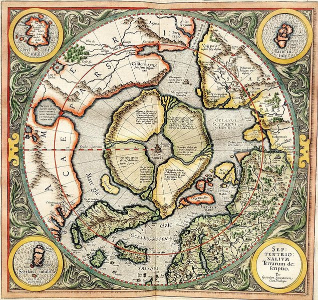
The magnetic mountain (center) and four surrounding continents as depicted by Mercator in 1595. Click for larger. (Wikimedia Commons)
But this detail is missing from De Virga’s map, and Thompson seems too eager to make into North America a piece of land of the size and shape of a territory well-known in 1414: Greenland. Further, in fifteenth century maps following Ptolemy, Greenland is depicted as connected to Europe, just as it is on De Virga’s map. But an even simpler answer is also at hand: the territory is named Norveca (Norway) and depicts that country. Thompson, conveniently, leaves out the geographic names to disguise this fact. I believe the space between Norway and Sweden, which Thompson sees as the Gulf of Mexico is intended to be the Gulf of Bothnia
The southern island he identifies as Peru is believed to be the result of De Virga conflating Marco Polo’s description of Japan and Java. (He uses Marco Polo’s geographic terminology extensively throughout the map.) The long and short of it is that what is known about the Inventio Fortunae tells us that the book describes the known geography of Greenland before including imaginary details about the Arctic drawn from Classical sources. In this, it is not significantly different from its contemporary, the Travels of Sir John Mandeville, another fictional work incorporating real fragments amidst outright fabrication and fantasy. There is no evidence that the Inventio Fortunae contained any information about North or South America. This is entirely modern speculation derived from a speculative interpretation of the (implied) lands separating the four seas that surround the magnetic mountain. So, given the lack of any other details matching what is known about Inventio Fortunae, which in turn was not written by Nicholas of Lynn, there is no reason to suspect that Albertin de Virga used imaginary details about America from the Inventio Fortunae to depict those continents on his world map. Thus, Gunnar Thompson's claim that Nicholas of Lynn voyaged to America in 1360, wrote the Inventio Fortunae, and inspired Albertin de Virga's world map of 1414 is false on every claim.
0 Comments
Your comment will be posted after it is approved.
Leave a Reply. |


AuthorI am an author and researcher focusing on pop culture, science, and history. Bylines: New Republic, Esquire, Slate, etc. There's more about me in the About Jason tab. 
Newsletters
Enter your email below to subscribe to my newsletter for updates on my latest projects, blog posts, and activities, and subscribe to Culture & Curiosities, my Substack newsletter.
Categories
All
Terms & ConditionsPlease read all applicable terms and conditions before posting a comment on this blog. Posting a comment constitutes your agreement to abide by the terms and conditions linked herein.
Archives
July 2024
|
- Home
- Blog
- Books
-
Articles
-
Newsletter
>
- Television Reviews >
- Book Reviews
- Galleries >
- Videos
-
Collection: Ancient Alien Fraud
>
- Chariots of the Gods at 50
- Secret History of Ancient Astronauts
- Of Atlantis and Aliens
- Aliens and Ancient Texts
- Profiles in Ancient Astronautics >
- Blunders in the Sky
- The Case of the False Quotes
- Alternative Authors' Quote Fraud
- David Childress & the Aliens
- Faking Ancient Art in Uzbekistan
- Intimations of Persecution
- Zecharia Sitchin's World
- Jesus' Alien Ancestors?
- Extraterrestrial Evolution?
- Collection: Skeptic Magazine >
- Collection: Ancient History >
- Collection: The Lovecraft Legacy >
- Collection: UFOs >
- Scholomance: The Devil's School
- Prehistory of Chupacabra
- The Templars, the Holy Grail, & Henry Sinclair
- Magicians of the Gods Review
- The Curse of the Pharaohs
- The Antediluvian Pyramid Myth
- Whitewashing American Prehistory
- James Dean's Cursed Porsche
-
Newsletter
>
-
The Library
-
Ancient Mysteries
>
-
Ancient Texts
>
- Mesopotamian Texts >
-
Egyptian Texts
>
- The Shipwrecked Sailor
- Dream Stela of Thutmose IV
- The Papyrus of Ani
- Classical Accounts of the Pyramids
- Inventory Stela
- Manetho
- Eratosthenes' King List
- The Story of Setna
- Leon of Pella
- Diodorus on Egyptian History
- On Isis and Osiris
- Famine Stela
- Old Egyptian Chronicle
- The Book of Sothis
- Horapollo
- Al-Maqrizi's King List
- Teshub and the Dragon
- Hermetica >
- Hesiod's Theogony
- Periplus of Hanno
- Ctesias' Indica
- Sanchuniathon
- Sima Qian
- Syncellus's Enoch Fragments
- The Book of Enoch
- Slavonic Enoch
- Sepher Yetzirah
- Tacitus' Germania
- De Dea Syria
- Aelian's Various Histories
- Julius Africanus' Chronography
- Eusebius' Chronicle
- Chinese Accounts of Rome
- Ancient Chinese Automaton
- The Orphic Argonautica
- Fragments of Panodorus
- Annianus on the Watchers
- The Watchers and Antediluvian Wisdom
-
Medieval Texts
>
- Medieval Legends of Ancient Egypt >
- The Hunt for Noah's Ark
- Isidore of Seville
- Book of Liang: Fusang
- Agobard on Magonia
- Book of Thousands
- Voyage of Saint Brendan
- Power of Art and of Nature
- Travels of Sir John Mandeville
- Yazidi Revelation and Black Book
- Al-Biruni on the Great Flood
- Voyage of the Zeno Brothers
- The Kensington Runestone (Hoax)
- Islamic Discovery of America
- The Aztec Creation Myth
-
Lost Civilizations
>
-
Atlantis
>
- Plato's Atlantis Dialogues >
- Fragments on Atlantis
- Panchaea: The Other Atlantis
- Eumalos on Atlantis (Hoax)
- Gómara on Atlantis
- Sardinia and Atlantis
- Santorini and Atlantis
- The Mound Builders and Atlantis
- Donnelly's Atlantis
- Atlantis in Morocco
- Atlantis and the Sea Peoples
- W. Scott-Elliot >
- The Lost Atlantis
- Atlantis in Africa
- How I Found Atlantis (Hoax)
- Termier on Atlantis
- The Critias and Minoan Crete
- Rebuttal to Termier
- Further Responses to Termier
- Flinders Petrie on Atlantis
- Amazing New Light (Hoax)
- Lost Cities >
- OOPARTs
- Oronteus Finaeus Antarctica Map
- Caucasians in Panama
- Jefferson's Excavation
- Fictitious Discoveries in America
- Against Diffusionism
- Tunnels Under Peru
- The Parahyba Inscription (Hoax)
- Mound Builders
- Gunung Padang
- Tales of Enchanted Islands
- The 1907 Ancient World Map Hoax
- The 1909 Grand Canyon Hoax
- The Interglacial Period
- Solving Oak Island
-
Atlantis
>
- Religious Conspiracies >
-
Giants in the Earth
>
-
Fossil Origins of Myths
>
- Fossil Teeth and Bones of Elephants
- Fossil Elephants
- Fossil Bones of Teutobochus
- Fossil Mammoths and Giants
- Giants' Bones Dug Out of the Earth
- Fossils and the Supernatural
- Fossils, Myth, and Pseudo-History
- Man During the Stone Age
- Fossil Bones and Giants
- Mastodon, Mammoth, and Man
- American Elephant Myths
- The Mammoth and the Flood
- Fossils and Myth
- Fossil Origin of the Cyclops
- History of Paleontology
- Fragments on Giants
- Manichaean Book of Giants
- Geoffrey on British Giants
- Alfonso X's Hermetic History of Giants
- Boccaccio and the Fossil 'Giant'
- Book of Howth
- Purchas His Pilgrimage
- Edmond Temple's 1827 Giant Investigation
- The Giants of Sardinia
- Giants and the Sons of God
- The Magnetism of Evil
- Tertiary Giants
- Smithsonian Giant Reports
- Early American Giants
- The Giant of Coahuila
- Jewish Encyclopedia on Giants
- Index of Giants
- Newspaper Accounts of Giants
- Lanier's A Book of Giants
-
Fossil Origins of Myths
>
-
Science and History
>
- Halley on Noah's Comet
- The Newport Tower
- Iron: The Stone from Heaven
- Ararat and the Ark
- Pyramid Facts and Fancies
- Argonauts before Homer
- The Deluge
- Crown Prince Rudolf on the Pyramids
- Old Mythology in New Apparel
- Blavatsky on Dinosaurs
- Teddy Roosevelt on Bigfoot
- Devil Worship in France
- Maspero's Review of Akhbar al-zaman
- The Holy Grail as Lucifer's Crown Jewel
- The Mutinous Sea
- The Rock Wall of Rockwall
- Fabulous Zoology
- The Origins of Talos
- Mexican Mythology
- Chinese Pyramids
- Maqrizi's Names of the Pharaohs
-
Extreme History
>
- Roman Empire Hoax
- American Antiquities
- American Cataclysms
- England, the Remnant of Judah
- Historical Chronology of the Mexicans
- Maspero on the Predynastic Sphinx
- Vestiges of the Mayas
- Ragnarok: The Age of Fire and Gravel
- Origins of the Egyptian People
- The Secret Doctrine >
- Phoenicians in America
- The Electric Ark
- Traces of European Influence
- Prince Henry Sinclair
- Pyramid Prophecies
- Templars of Ancient Mexico
- Chronology and the "Riddle of the Sphinx"
- The Faith of Ancient Egypt
- Remarkable Discoveries Within the Sphinx (Hoax)
- Spirit of the Hour in Archaeology
- Book of the Damned
- Great Pyramid As Noah's Ark
- Richard Shaver's Proofs
-
Ancient Texts
>
-
Alien Encounters
>
-
US Government Ancient Astronaut Files
>
- Fortean Society and Columbus
- Inquiry into Shaver and Palmer
- The Skyfort Document
- Whirling Wheels
- Denver Ancient Astronaut Lecture
- Soviet Search for Lemuria
- Visitors from Outer Space
- Unidentified Flying Objects (Abstract)
- "Flying Saucers"? They're a Myth
- UFO Hypothesis Survival Questions
- Air Force Academy UFO Textbook
- The Condon Report on Ancient Astronauts
- Atlantis Discovery Telegrams
- Ancient Astronaut Society Telegram
- Noah's Ark Cables
- The Von Daniken Letter
- CIA Psychic Probe of Ancient Mars
- Scott Wolter Lawsuit
- UFOs in Ancient China
- CIA Report on Noah's Ark
- CIA Noah's Ark Memos
- Congressional Ancient Aliens Testimony
- Ancient Astronaut and Nibiru Email
- Congressional Ancient Mars Hearing
- House UFO Hearing
- Ancient Extraterrestrials >
- A Message from Mars
- Saucer Mystery Solved?
- Orville Wright on UFOs
- Interdimensional Flying Saucers
- Poltergeist UFOs
- Flying Saucers Are Real
- Report on UFOs
-
US Government Ancient Astronaut Files
>
-
The Supernatural
>
- The Devils of Loudun
- Sublime and Beautiful
- Voltaire on Vampires
- Demonology and Witchcraft
- Thaumaturgia
- Bulgarian Vampires
- Religion and Evolution
- Transylvanian Superstitions
- Defining a Zombie
- Dread of the Supernatural
- Vampires
- Werewolves and Vampires and Ghouls
- Science and Fairy Stories
- The Cursed Car
-
Classic Fiction
>
- Lucian's True History
- Some Words with a Mummy
- The Coming Race
- King Solomon's Mines
- An Inhabitant of Carcosa
- The Xipéhuz
- Lot No. 249
- The Novel of the Black Seal
- The Island of Doctor Moreau
- Pharaoh's Curse
- Edison's Conquest of Mars
- The Lost Continent
- Count Magnus
- The Mysterious Stranger
- The Wendigo
- Sredni Vashtar
- The Lost World
- The Red One
- H. P. Lovecraft >
- The Skeptical Poltergeist
- The Corpse on the Grating
- The Second Satellite
- Queen of the Black Coast
- A Martian Odyssey
- Classic Genre Movies
-
Miscellaneous Documents
>
- The Balloon-Hoax
- A Problem in Greek Ethics
- The Migration of Symbols
- The Gospel of Intensity
- De Profundis
- The Life and Death of Crown Prince Rudolf
- The Bathtub Hoax
- Crown Prince Rudolf's Letters
- Position of Viking Women
- Employment of Homosexuals
- James Dean's Scrapbook
- James Dean's Love Letters
- The Amazing James Dean Hoax!
- James Dean, The Human Ashtray
- Free Classic Pseudohistory eBooks
-
Ancient Mysteries
>
- About Jason
- Search


 RSS Feed

© 2010-2024 Jason Colavito. All rights reserved.